Showing posts with label Alcatel. Show all posts

Sunday, 24 July 2016

Review of Alcatel Pop D1 for navigation: 3. ViewRanger further testing

In part 2 of this review I reviewed ViewRanger on a basic Android 4 phone.  I've used it on and off frequently now and have found that it even works well as a 3G modem as a tether to a tablet on a budget £5 Virgin SIM.

This post is just as a brief update to comment on today's use. This is the first time that I've used the GPS all day as my principle mapping and GPS device. We walked for a little under 18 miles in around 8 hours. The battery was freshly charged before setting off and at the end of the hike it was down to 69% charge. That implies it might mange 24 hours. I checked the route occasionally but I must confess that I know much of the route from memory and so the screen wasn't activated very often.  The GPS was being repeatedly activated by a helper app but the phone was in 'airplane mode' to disable 3G and WiFi sections.

Note that this is a 1:25 000 OS map

 The screenshot gives an indication of the GPS accuracy. The wooded section in the Haddon Hall estate just east of Bakewell has substantial tree cover and the contours are such that it is in a gulley. This is as good as one could expect from a retail GPS unit.

The sun was mostly screened by mist although I'd classify the day as 'bright'. The screen was readable throughout.

Monday, 2 May 2016

Review of Alcatel Pop D1 for navigation: 2. ViewRanger in use

Part 1 of this review is available here and outlines my budget setup.

I've been trialling ViewRanger for a few weeks now and have gradually refined its use on Android.  The ActiveGPS seems pivotal in keeping the GPS running during sleep. Aeroplane mode is worth activating to disable WiFi and 3G which both enhances battery life and removes interruptions from the outdoor experience.

As can be seen in the image recording of a track is as good as can be expected from a consumer 12 channel device. For most of the track the trace overlies the mapping whilst on other occasions it runs parallel within 50m or so. Note that the marked deviation from the Right of Way to the north of the 'Bird Sanctuary' accurately represents additional paths not shown on the map. The woods are mixed woodland and at this time of year the leaf cover is is slight so not an especially tough GPS environment. I have carried the phone in the front pocket of a rucsac so it is reasonable to assume the antenna is vertical, and thus probably sub-optimally orientated, but well exposed to the sky.

Track recording shown in red overlayed on OS 1:50000 
I've found this degree of accuracy consistently now and will monitor different areas (valleys, leaf coverage) to see how well it is maintained.

Route following is an important feature of ViewRanger and a leap beyond the limitation of 20 points on my old GPS12XL as there appears to be no limit to the number of waypoints on a route. I'm sure that there is a technical limit but it's considerable, not indicated in the product documentation and certainly exceeds anything likely to be needed. Online route planning is very easy with access to any premium maps that have been purchased. Route making on the small screen Android interface is possible but a little bit fiddly. If the phone is online it's an easy task to synchronise routes between the website and the phone or vice versa in a matter of moments.

The manner in which ViewRanger follows a route is quite complicated and only clear once the documentation is studied.  I don't think that I have the parameters optimised just yet for the arrival and arrived distances and certainly the cross track distance must be adjusted to suit likely GPS errors. If the cross track error is set too narrow the alarm sounds frequently and the software replays the route which might cause confusion. I discovered problems here before I installed ActiveGPS as the sleeping GPS generated off-track data when it was polled by ViewRanger.

The major problem so far is the limited brightness of the screen which makes it hard to read on sunny days. As I've only tested the setup during an English springtime to date it is possible that the device will be useless in Spanish sunshine.

Friday, 15 April 2016

Review of Alcatel Pop D1 for navigation: 1. Viewranger meets Android

Part 0 of this review is available here.

GPS linked with mapping is now well established and exemplified by products such as Garmin's Oregon, Montana and GPSMAP64 series devices. These are well known products that are accepted to be pretty reliable although there are some known limitations of the software.


To me, the major limitation is the restricted options for mapping and often high prices for high quality topographic maps. Several third parties, for example talkytoaster, provide packed versions of OpenStreetMap open source maps which does broaden the options for affordable mapping.

Sample from Look n feel by TT
Strangely OS mapping licensed to ViewRanger is far better priced than Garmin's especially as it can be bought per tile or in various discount packs.  ViewRanger also offer OSM mapping and licensed worldwide mapping. In principle the ViewRanger mapping base appears more user-orientated than Garmin's.

ViewRanger runs via a web browser on PCs and this component provides a great resource for designing routes and looking for interesting features on a map - you can use any free maps or tiles that you have purchased. More importantly the system runs as an App on Android, iOS and Symbian platforms thus covering the vast majority of smartphones. It is worth stressing that both the  desktop and mobile programmes are free, you only pay for licensed mapping.

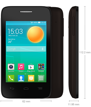
After a little online searching I found a new Alcatel Pop D1 for sale on eBay for £32 including delivery. This is a dual core Android 4.4 device with a basic specification (512MB RAM, 4GB flash) including 12 channel GPS. The 'obsolete' smartphone market is very fluid so any given day other devices will be available.


The unit is clearly made to a budget with a plastic body and screen, all of which flex under pressure. The battery is removable which is helpful and the standard Sim and microSD easy to fit. I used a 8GB microsSD to make sure that I'd plenty of space.

The phone was readily charged and set-up with ViewRanger. I deleted as many of the bundled games as possible but some of the apps are built-in and can't be deleted. They can be deactivated though. With a bit of tidying the key icons can be fitted onto a single screen so there's no need to swipe, or more importantly, the option of swiping and hiding ViewRanger! I made a new Google account and haven't linked it to my mail/blog/calendar/paypal accounts so that I don't need to set any security. From previously using my Nexus tablet out of doors I knew that having to type in passcode was irritating whilst walking. Of course now I'm at risk of losing some credit from my SIM if the phone is stolen but again that is a new account and a SIM isn't required for GPS.

The phone boots-up in 45seconds with ViewRanger starting in 12 seconds until a map is displayed and centred to the previous known position.  GPS acquisition is varied as is the case for all devices but 30s seems sufficient in most cases.

In early tests I found that the GPS was powering down as the phone went to sleep which is great for battery life but not for navigation. I tried various settings in ViewRanger to keep the GPS switched on but none seemed to work. After a bit of online searching I found that this was a known problem. There are various Apps on GooglePlay that aims to force the GPS to keep running and I found that  ActiveGPS seems to work best for this combination of hardware and app.

Saturday, 9 April 2016

Morning runs again?

Nine weeks ago was the last time that I ran on a Saturday morning and although I managed 14km it was too uncomfortable to want to try again. Now my gut disturbance has been much improved for 6 days such that I've not suffered from pain at all.

Today the Cofield pool was on 9am opening with 9am children's lessons  so I'd have had no chance of a decent swim. My arms and shoulders still feel a little tired and achy from the last 2 weeks of hard work so perhaps that was a good thing.  So, with supposedly pain-free guts I ran around the woods. I had been tempted to do a half-marathon route but that would have been stupid after not managing anything over 10km, and nothing before 17:00 for literally months. A longer run can be done another week when I'm sure I'm a bit more in training and not going to take a step backwards.

Ecclesall Woods are always lovely so I completed a 9km loop, including a slight extension as I was feeling fine!

From Alcatel Pop D1 Android phone,
I wasn't rushing and took the opportunity to trial the Alcatel Pop D1 a little further on both Tracking and photography. The camera isn't great, it does get the essence of a scene but nothing more. The GPS worked a little better than previously and I'll write about that elsewhere.